Rosanne
As usual I follow all the threads in this section and the links provided. After the Behenian Stars thread and Bardic Origins and most importantly DianaOD's research in to Charles VI cards; my own interest in things Astronomical, Phoenician Abjads, Mamluk cards, Sicily,and the wondering of Tarot and it's beginnings through the images we have now; I purchased a book called Mapping the World by Michael Swift. It is a wonderful resource and might be considered a coffee table book if you have a huge coffee table. It is full of maps from what is still around; mostly what is around to be reproduced is because all maps were, of course, drawn and illuminated by hand, which made the distribution of maps extremely limited; and also they were commissioned for the elite. Many were not intended for navigating, but were considered works of art.
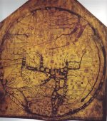
Between 500 AD and 1450 AD called the 'Dark Ages' in Europe (this followed the collapse of the Roman empire and the 'decline of western civilization', the rise of Christianity but more directly the decline of the sciences: "The lamp of scientific knowledge was obscured by the light of religious ecstasy"), knowledge and maps, resided in the hands of religious scribes, who tended to support references in the bible rather than depicting geographic facts, and supporting the idea of a 'flat' earth The earth was drawn as a circle with EAST (Orient) to the top and Jerusalem in the centre. "This is Jerusalem., I have set it in the midst" (Ezekiel 5.5)
The known world was bordered by Cold (N), Heat(S), Ocean (W), Paradise (E); maps of this time are known as "T-in-O" maps. Letter O for the circle of the earth, T formed by Mediterranean (vertical) and Don and Nile (horizontal), separating Asia, Europe and Africa.
There I was looking at two T-in-O maps- the TdM La Monde and the Visconti Il Mondo.
I remembered that as far as Maps went in early Medieval Europe they were often more allegorical or ecclesiastical than cartographic. As I said before during the Medieval period, European maps were dominated by religious views. The T-in-O map was common. So the T has become Christ or Fortune- the device was adapted. The circle became a madorla as in many illustrations and the scarf is sometimes Christ's Cloak and sometimes Fortune's scarf; the known borders become the Evangalists. Maybe today we would border the O with a Sword,Cup,Wand and Coin(and forever argue what goes where).
So if the La Monde was a T-in-O map, it seems very logical that other images from Tarot might well be too.
http://academic.emporia.edu/aberjame/map/h_map/h_map13.jpg
There is more to tell but maybe I will wait and see if this is interesting enough because after 1450 some amazing things happened in the mapping world.....
Thanks to Kwaw for all the bits and pieces he provides, and to DianaOD for her essays that focussed my search. ~Rosanne
")